Over on YouTube icholakov has uploaded a video showing how effective a simple old TV bunny ears antenna can be at receiving NOAA satellite images. The old TV antenna is telescoping so it can be adjusted to be resonant for many frequencies, and for NOAA satellites about 20 inches makes it resonant. Using the antenna as a V-Dipole and placing it in a North to South direction optimizes the radiation pattern towards the sky, allowing for good reception of the NOAA satellite. Using it this way also helps to null out strong vertically polarized stations. More information on the V-Dipole can be found on our previous post where we posted about Adam 9A4QV’s idea to use the V-Dipole for satellite reception.
Also related to this post is a sneak preview on our new product: We’ve also caught onto the idea that TV antenna dipoles are extremely versatile, and are in the final stages of releasing a simple telescopic dipole product similar to the TV antenna used in this video. It will be released as an antenna set that comes with some portable mounting solutions like a suction cup and bendy tripod, and 3M of RG174 coax so that the antenna can be used anywhere. Target price is $10 -15 USD incl. shipping from China. This will probably also replace the stock telescopic whip antenna currently used in our dongle sets since the telescopic dipole is simply much more versatile.
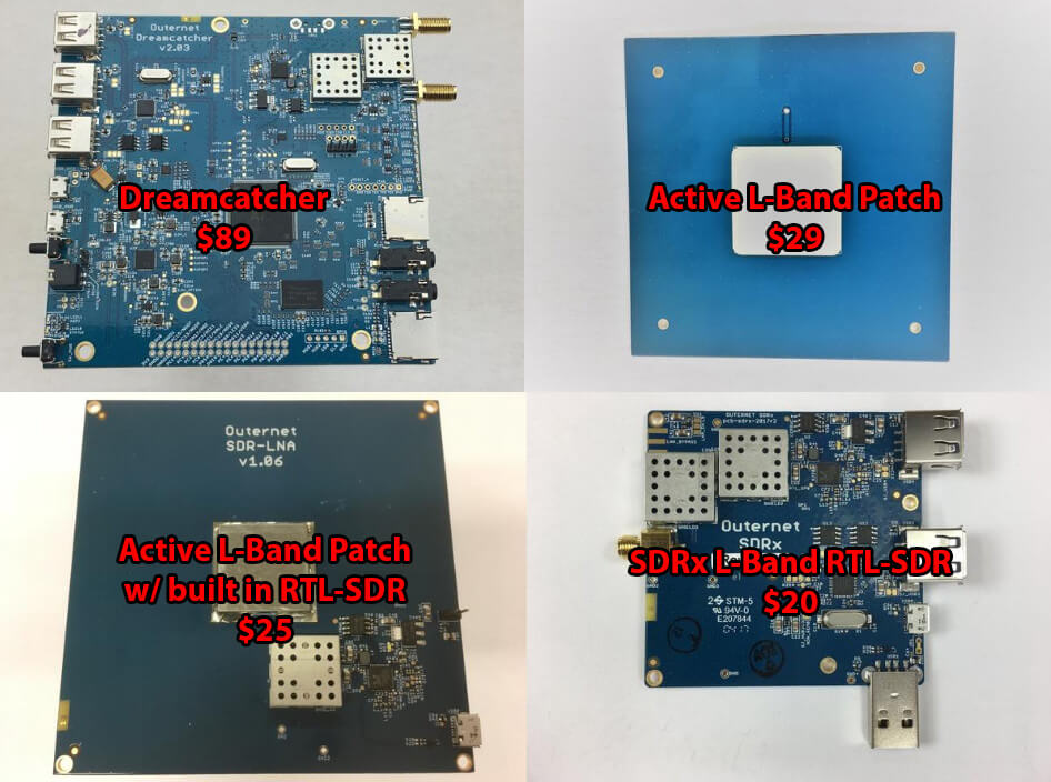
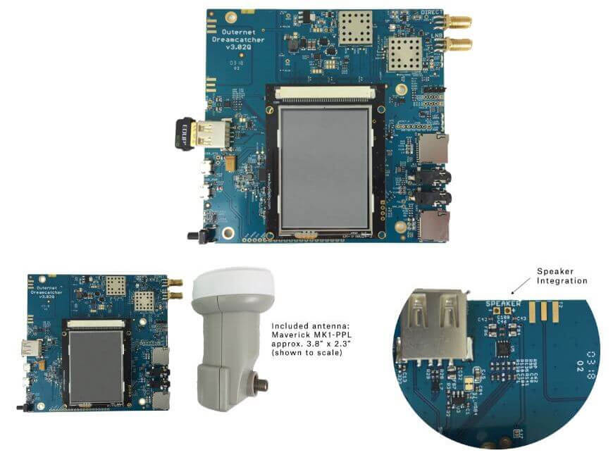
Back in June we tested Outernet’s new Dreamcatcher which is an ARM based computing board with RTL-SDR and L-band LNA built in. The $99 USD kit also included an external active L-band patch antenna. The Dreamcatcher full kit has now been reduced to $89 USD, and the active L-band patch antenna can also now be purchased by itself for $29 USD. The active patch antenna is also compatible with the bias tee on our V3 dongles and is a good low cost option for exploring most L-band satellite signals like Outernet, Inmarsat STD-C and AERO around 1542 MHz. The filter does unfortunately cut off the higher Iridium frequencies though.
They are also selling off their older L-band SDRx RTL-SDR boards at a reduced price of $20 USD. The SDRx is a RTL-SDR PCB with a built in L-band LNA and filter, but unlike the Dreamcatcher does not have built in computing hardware. They also have a limited $25 USD edition version of their active patch antenna which includes a built in RTL-SDR. This version is a bit more noisy compared to the standard active patch, but may be an interesting experimental antenna for some.
Leandvb is command line based lightweight DVB-S decoder designed for receiving Digital Amateur TV, including signals like HamTV from the International Space Station. The RTL-SDR can be used together with leandvb and it turns out that leandvb can also be used to decode the Outernet signal. If you were unaware, Outernet is a free L-band based satellite service that provides content such as news, weather data, APRS repeats and more. Currently you can get about 20MB of data a day. Outernet receivers are also all based around the RTL-SDR, allowing for very cheap receivers to be built. At the moment you’ll need a C.H.I.P or their specialized Dreamcatcher hardware to run their special Skylark OS with software decoder, but a general Armbian decoder is in the works.
Alternatively leandvb can be used, and over on their website the folks behind the leandvb software have uploaded a tutorial showing how to use leandvb to decode Outernet. Thanks to some reverse engineering attempts by Daniel Estévez, it was discovered that the Outernet modulation is very similar to DVB-S so the standard decoder can be used with some custom flags. Leandvb only outputs raw frames, not decoded data. They haven’t tested it, but it may be possible to feed the frames into Daniel Estevez’s free-outernet project for obtaining the final files.
During the testing they also discovered some interesting notes about the E4000 and R820T RTL-SDRs. For example by patching the R820T2 drivers to add some additional VGA gain they were able to make the R820T2 chips more sensitive at the Outernet frequency compared to the E4000 chip by bringing the signal further out of the quantization noise. They also tested a 60cm dish vs a patch antenna and found that the dish works significantly better.
Manuel a.k.a ‘Tysonpower’ has been using his RTL-SDR (and his Baofeng) to listen in on ARISS contacts from the International Space Station (ISS). ARISS stands for Amateur Radio on the ISS, and is a program often used by schools to allow students to contact and ask questions to astronauts on the ISS with a ham radio. It is possible for anyone to listen in on the downlink (astronaut speech) if the ISS is over your location while transmitting. The uplink however may not be able to be heard as the signal is directed upwards towards the station.
For his first try he used a Baofeng (cheap Chinese handheld) and a DIY Carbon Yagi. For the second contact he used his RTL-SDR V3, an FM Trap and an LNA4ALL on a V-Dipole antenna placed on the roof of his car. With this set up he was able to receive the downlink transmissions from 1.6 degrees to 1.3 degrees elevation.
Bitcoin is the worlds first and most popular digital currency. It is steadily gaining in value and popularity and is already accepted in many online stores as a payment method. In order to use Bitcoin you first need to download a large database file called a ‘blockchain’, which is currently at about 152 GB in size (size data obtained here). The blockchain is essentially a public ledger of every single Bitcoin transaction that has ever been made. The Bitcoin software that you install initially downloads the entire blockchain and then constantly downloads updates to the blockchain, allowing you to see and receive new payments.
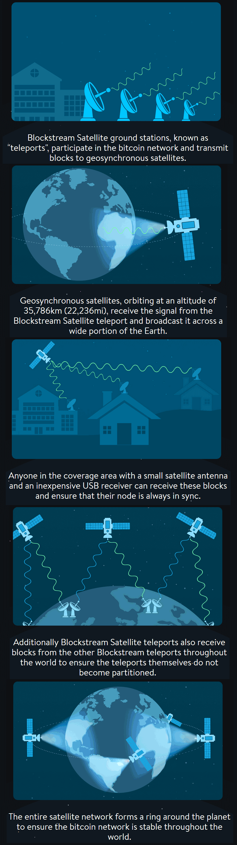
Blockstream is a digital currency technology innovator who have recently announced their “Blockstream satellite” service. The purpose of the satellite is to broadcast the Bitcoin blockchain to everyone in the world via satellite RF signals, so that even in areas without an internet connection the blockchain can be received. Also, one problem with Bitcoin is that in the course of a month the software can download over 8.7 GB of new blockchain data, and there is also the initial 152 GB download (although apparently at the moment only new blocks are transmitted). The satellite download service appears to be free, so people with heavily metered or slow connections (e.g. 3G mobile which is the most common internet connection in the third world/rural) can benefit from this service as well.
The service appears to be somewhat similar to the first iteration of the Outernet project in that data is broadcast down to earth from satellites and an R820T RTL-SDR is used to receive it. The blockstream satellite uses signals in the Ku band which is between 11.7 to 12.7 GHz. An LNB is required to bring those frequencies back down into a range receivable by the RTL-SDR, and a dish antenna is required as well. They recommend a dish size of at least 45 cm in diameter. The signal is broadcast from already existing satellites (like Outernet they are renting bandwidth on existing satellites) and already 2/3 of the earth is covered. The software is based on a GNU Radio program, and can be modified to support any SDR that is compatible with GNU Radio. They write that the whole setup should cost less that $100 USD to purchase and set up.
To set it up you just need to mount your satellite antenna and point it towards the satellite broadcasting the signal in your area, connect up your LNB and RTL-SDR and then run the software on your PC that has GNU Radio installed.
More details can be found on the Blockstream Satellite website, and technical details about the software and hardware required can be found on their GitHub page.
How the Blockchain satellite works (From blockstream.com/satellite/howitworks/)
Some may wonder what’s the point if you can’t transmit to the service to make payments with it. Over on this Bitcoin Reddit thread user “ideit” explains why it’s still useful in this nice quote.
You sell goats in a small village. A customer wants to buy a goat, but you have no banks so people have put their money into bitcoin. Your customer goes to the village center which has a few computers hooked up to the internet. He sends you payment then comes to get his goat. You don’t have internet near your goat farm, but you’re connected to the satellite so you can see he sent you payment and you give him his goat.
Or, you live in an area that caps your bandwidth. You want to run a full node, but downloading blocks eats away at your cap. Connecting to a satellite reduces your bandwidth usage.
Or, you’re using an air gapped laptop to sign transactions from your wallet for security reasons. You can now connect that laptop to the satellites so your laptop can generate its own transactions without connecting to the internet.
Or, your internet connection is terrible. You can usually broadcast transactions since they’re small, but downloading blocks and staying in sync with the blockchain is literally impossible. Connect to a satellite and now it’s simple.
Thanks to Dave for submitting news of his recent release of his Python script called dopplerscript. This is a tool that can help people automate the reception and decoding of the Meteor M2 weather satellite in Linux with GNU Radio by providing a tool for automatic Doppler correction. He writes:
gr-gpredict-doppler is an out-of-tree gnuradio block for getting doppler updates from gpredict into a flowgraph. I’ve written a small python script (based on pyephem) that replaces gpredict for generating the doppler updates. This script allows one to automate scripting the reception of Meteor M2 satellite transmissions while compensating for the doppler shift.
dopplerscript is a command-line tool to input satellite doppler shifts into a gnuradio flowgraph. The doppler.py script replaces gpredict as the source for doppler frequency updates in gr-gpredict-doppler, making it easy to script satellite reception.
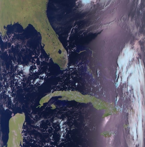
As low earth orbit satellites fly very quickly overhead, the signal will be affected by the doppler effect, thus shifting the frequency as it moves towards and away from you. Tools like this can be used to predict and compensate for this effect and thus providing better signal processing. Meteor M2 is a Russian weather satellite in low earth orbit which transmits digital LRPT weather satellite images that can be received with an RTL-SDR or other SDR.
An Example LRPT Image Received with an RTL-SDR from Meteor M2.
Over on YouTube user Tysonpower has uploaded a video showing how he was (almost) able to receive the HRPT signal from NOAA18 with an ADALM-PLUTO, LNA4ALL and a WiFi grid antenna.
Most readers will be familiar with the low resolution 137 MHz APT weather satellite images transmitted by the NOAA weather satellites. But NOAA 15, 18, 19 and well as Metop-A and Feng Yun satellites also transmit an HRPT (High Resolution Picture Transmission) signal up in the 1.7 GHz region. These HRPT images are much nicer to look at with a high 1.1 km resolution. If you follow @usa_satcom on Twitter you can see some HRPT images that he uploads every now and then.
However HRPT is quite difficult to receive and decode because the bandwidth is about 3 MHz so something with more bandwidth than an RTL-SDR is required. The signal also needs a ~1 meter or larger dish antenna as it is very weak, and you also need a motorized pointing system to track the satellite with the dish as it passes over.
Despite the difficulty in his video Tysonpower showed that he was able to at least receive a weak signal using a non-optimal 2.4 GHz WiFi grid dish antenna, LNA4ALL and his ADALM-PLUTO. The signal is far too weak to actually decode, but it’s still pretty surprising to receive it at all. In the future Tysonpower hopes to be able to improve his system and actually get some image decodes going. Note that the video is in German, but there are English subtitles available.
Over on his YouTube channel user Tysonpower has uploaded a video that shows how to make a V-Dipole antenna. Back in March we posted about the V-Dipole which Adam 9A4QV first described. A V-Dipole is a simple antenna that normally consists of two metal rods, a terminal block and coax cable. It is particularly effective for reception of low Earth orbit satellites like the NOAA and Meteor M2 weather image satellites with an RTL-SDR or other similar SDR.
In his video Tysonpower shows how to build a slightly more rugged version using a 3D printed part instead of a terminal block. Aluminum welding rods are used for the elements. The 3D printed part ensures that the correct 120 degree ‘V’ angle is maintained and also provides a means for mounting the antenna to a pole. The 3D printing STL files are available on Thingiverse. Note that the video is in German, but English subtitles are available.
Over on his YouTube channel GusGorman402 has uploaded a video that shows how he was able to capture and decode data from a USGS (United States Geological Service) streamgage.
A streamgage is a sensor for streams and rivers that is used for measuring the amount of water flowing. In particular the ALERT (Automated Local Evaluation in Real-Time) streamgages are designed for the warning of flooding. The ALERT streamgages are wireless with some transmitting data upwards to the GOES-15 geosynchronous satellite with a cross Yagi and some transmitting locally via a standard Yagi. Gus shows if you’re close to a streamgage antenna then you can still receive the signal on the ground with an RTL-SDR. Gus also mentions that all streamgages in his area are slowly being converted to satellite uplink.
His first video simply shows the RTL-SDR receiving a Streamgage satellite uplink signal at 400 MHz. In his second video he moves to a streamgage with terrestrial link at 170 MHz and shows that the data can actually be decoded into a binary string using minimodem. Another program called udfc-node can then be used to turn the data into a human readable format. The binary packets consist of an address that identifies the particular streamgage, and some data that describes the current level of the stream and how much precipitation it has counted.
A few months ago satellite data broadcasting company Outernet created a limited number of prototype receivers that combined an L-band satellite patch antenna, LNA and RTL-SDR into a signal unit. This was never produced in bulk as they found it to be too noisy having the RTL-SDR so close to the antenna, but nevertheless it still worked fairly well.
Over on YouTube max30max31 bought one of these prototype units and made a video about using it for receiving and decoding various L-band satellite signals. In the video he first shows an overview of the product and then shows it receiving and/or decoding some signals like Inmarsat STD-C, AERO and Inmarsat MFSK.
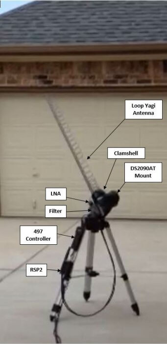
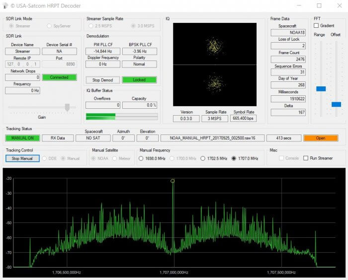
Over on the SDRplay forums user 'RSP2user' has put up a quality post describing how he receives HRPT weather satellite images with his SDRplay RSP2. HRPT stands for 'High Resolution Picture Transmission' and provides a much higher resolution image compared to the APT weather satellite images typically downloaded from NOAA satellites. Somewhat confusingly the picture quality of HRPT is similar to LRPT (low rate picture transmission) which is used on the Russian Meteor M series weather satellite. HRPT provides 1.1 km resolution, whilst LRPT provides 1 km resolution.
Currently there are multiple satellites broadcasting HRPT signals including NOAA 19, NOAA 18, NOAA 15, Meteor M2, Fengyun 3B, Fengyun 3C, Metop A and Metop B.
The difference in difficulty of receiving APT and LRPT versus HRPT transmissions typically occur in the L-band at about 1.7 GHz, and requires a directive high gain antenna with tracking motor to track the satellite as it passes over. This makes these images many times more difficult to receive compared to APT and LRPT which only require a fixed position antenna for reception at the more forgiving 137 MHz.
Over on his post RSP2user shows how he uses a repurposed Meade Instruments telescope tracking mount and controller to drive the tracking of a 26 element loop Yagi antenna. A 0.36dB noise figure LNA modified with bias tee input is used to boost the signal and reduce the noise figure. The signal is received by a SDRplay RSP2 and processed on a PC with USA-satcoms HRPT decoder software, which is available for purchase by directly contacting him. The HRPT signal bandwidth appears to be about 2.4 MHz so possibly an RTL-SDR could also be used, but it might be pushing it to the limit.
If you are interested, RSP2user also uploaded an APT weather satellite image reception tutorial on another post. This tutorial shows how to build a quality quadrifilar helix antenna as well.
Receiving the HRPT signal on USA-Satcoms' HRPT decoder.
Over the past few years we've posted quite a bit about Outernet who offered a free downlink of satellite data such as news, Wikipedia articles and weather updates that was able to be received with a small L-band patch antenna, LNA and an RTL-SDR dongle.
Firstly the downlink data rate is much higher at 30kbps, with the plan to eventually go up to 100kpbs. That's 300MB - 1 GB a day which is a lot more compared to the previous L-band implementation that gave less than 20MB a day.
Secondly the hardware seems to be simplified as well. All that is needed is their new Dreamcatcher V3 receiver board and a small Ku-band LNB (11.7-12.75 GHz). They claim that no dish is required as the LNB pointed at the satellite by itself will work just fine. The first iteration of Outernet also used Ku-band satellites, but required a large dish antenna to receive it which was a major hurdle to user adoption. They now appear to have discovered a new way to broadcast in the Ku-band without the need for a dish.
Thirdly, moving to Ku-band means significant cost savings for Outernet allowing them to survive and continue with their free data service. From what we understand the L-Band satellite downlink service is extremely costly to run, whereas a Ku-band service is much cheaper. There are also cost savings for the user as Ku-band LNBs are very common hardware that can be found cheaply for $10 - $20 US.
About the new services that they can offer and the cost savings that they can achieve Syed the CEO of Outernet writes:
The fatter pipe [300MB - 1GB] makes a lot of things possible, one of which is a true radio broadcast. How about a national radio broadcast that isn't SiriusXM? Our new receiver will include a speaker; audio through the speaker while files download in the background. But more data is not the most important thing that comes out of all this. The real win is that leasing standard, commodity Ku bandwidth is far, far more cost effective than the few kilohertz we have on L-band. Long-term sustainability of a free broadcast is no longer the financial burden that it once was--especially considering how much more interesting the service becomes.
There is no concrete hardware release date just yet, but on the forums Syed estimates mid-Jan. You can sign up to the Outernet mailing list on their buy-now page to be emailed when the new hardware is released. In the forums Syed also writes that the target price for the hardware is $99 US, with the intention to provide lower cost options in the future. Of course it might still be possible to DIY your own unit just like it was with the previous Outernet iterations.
We're really looking forward to this and think that this is what will finally make Outernet a very popular and useful service!
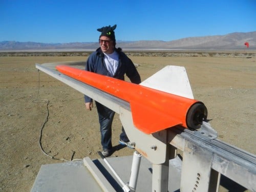
Back in April and July of last year we posted about Philip Hahn and Paul Breed's experiments to use an RTL-SDR for GPS logging on their high powered small rockets. Basically they hope to be able to use an RTL-SDR combined with a computing platform like a Raspberry Pi or Intel Compute stick and software like gnss-sdr to record GPS data on their rocket. Using an RTL-SDR would get around the COCOM limits that essentially stop GPS from working if it measures faster than 1,900 kmph/1,200 mph and/or higher than 18,000 m/59,000 ft.
In the past they've been able to get usable data from the flights, but have had trouble with reliability and noise. That said they also tried commercial GPS solutions which have also failed to work properly even on flights travelling under the COCOM limits, whereas the RTL-SDR actually got data that could still be post processed.
If you are interested in a full summary of Phillip and Paul's experiments, then the GNU Radio blog has a nice summary written by Phillip that explains their full journey of trying to get a working RTL-SDR based GPS system for their rockets.
Rocket Trajectory as measured by the RTL-SDR based GPS receiver.
Outernet Dreamcatcher Board running with a cheap satellite TV LNB
Outernet 3.0 is gearing up for launch soon, and just today they've released a blog post introducing us to the RF protocol technology behind the new service. If you weren't already aware, Outernet is a free satellite based information service that aims to be a sort of 'library in the sky'. Their aim to to have satellites constantly broadcasting down weather, news, books, radio, web pages, and files to everyone in the world. As it's satellite based this is censorship resistant, and useful for remote/marine areas without or with slow/capped internet access.
Originally a few years ago they started with a 12 GHz DVB-S satellites service that gave 1GB of content a day, but that service required a large dish antenna which severely hampered user adoption. Their second attempt was with an L-band service that only needed a small patch antenna. This service used RTL-SDR dongles as the receiver, so it was very cheap to set up. Unfortunately the L-band service had a very slow data rates (less than 20MB of content a day), and leasing an L-band transmitter on a satellite proved to be far too expensive for Outernet to continue with. Both these services have now been discontinued.
Outernet 3.0 aims to fix their previous issues, giving us a service that provides over 300MB of data a day, with a relatively cheap US$99 receiver that is small and easy to set up. The new receiver uses a standard Ku-Band LNB as the antenna, which is very cheaply available as they are often used for satellite TV reception. The receiver itself is a custom PCB containing a hardware (non-SDR based) receiver with a LoRa decoder.
LoRa is an RF protocol that is most often associated with small Internet of Things (IoT) devices, but Outernet have chosen it as their satellite protocol for Outernet 3.0 because it is very tolerant to interference. In Outernet 3.0 the LNB is pointed directly at the satellite without any directive satellite dish, meaning that interference from other satellites can be a problem. But LoRa solves that by being tolerant to interference. From the uplink facility to the satellite and back to their base in Chicago the LoRa signal travels 71,572 km, making it the longest LoRa signal ever transmitted.
According to notes in their forums Outernet 3.0 is going to be first available only in North America. Europe should follow shortly after, and then eventually other regions too. When ready, their 'Dreamcatcher 3.0' receiver and computing hardware is expected to be released for US$99 on their store. You can sign up for their email list on that page to be notified upon release.
Also as a bonus, for those interested in just LoRa, the Dreamcatcher 3.0 is also going to be able to transmit LoRa at frequencies anywhere between 1 MHz to 6 GHz, making it great for setting up long range LoRa links. This might be an interesting idea for hams to play with.
Thanks to Andrey for writing in and showing us his Java based Meteor-M decoder for the RTL-SDR which he uses on a Raspberry Pi. The decoder is based on the meteor-m2-lrpt GNU Radio script and the meteor_decoder which he ported over to Java. Essentially what he's done is port over to Java a bunch of GNU Radio blocks as well as the meteor decoder. The ported Java blocks could also be useful for other projects that want to be cross platform or run without the need for GNU Radio to be installed.
In his blog post (blog post is in Russian, use Google Translate for English) Andrey explains his motivation for writing the software which was that the Windows work flow with SDR# and LRPTofflineDecoder is quite convoluted and cannot be run headless on a Raspberry Pi. He then goes on to explain the decoding algorithm, and some code optimizations that he used in Java to speed up the decoding. Andrey notes that his Java version is almost 2x slower compared to the GNU Radio version, but still fast enough for real time demodulation.
Meteor-M2 is a Russian weather satellite that operates in the 137 MHz weather satellite band. With an RTL-SDR and satellite antenna these images can be received. Running on a Raspberry Pi allows you to set up a permanent weather satellite station that will consistently download images as the satellite passes over.
Images received with Andry's Meteor-M software running on a Raspberry Pi.
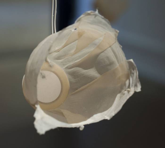
One of the piezo speakers playing the satellite transmissions.
In the past we've seen software defined radio's like the HackRF use to create art installations such as the 'Holypager', which was an art project that aimed to draw attention to the breach of privacy caused by pagers used by doctors and staff at hospitals.
Recently another art installation involving a software defined radio was exhibited at Wichita State University. The project by artist Nicholas A. Knouf is called "they transmitted continuously / but our times rarely aligned / and their signals dissipated in the æther" and it aims to collect the sounds of various satellite transmissions, and play them back using small piezo speakers in the art gallery. To do this he built a SatNOGS receiver and used a software defined radio to capture the audio. He doesn't mention which SDR was used, but most commonly RTL-SDR's are used with the SatNOGS project. Nicholas describes the project below:
This 20-channel sound installation represents the results of collecting hundreds of transmissions from satellites orbiting the earth. Using custom antennas that I built from scratch, I tracked the orbits and frequencies of satellites using specialized software. This software then allows me to collect the radio frequency signals and translate them into sound.
The open source software and hardware, called SatNOGS and developed by a world-wide group of satellite enthusiasts, enables anyone to build a ground station for tracking satellites and their transmissions, which are then uploaded to a publicly accessable database. Data received by my ground stations can be found here. These transmissions are mostly from weather satellites, CubeSats (small satellites launched by universities world-wide for short-term research), or amateur radio repeaters (satellites designed for ham radio operators to experiment with communication over long distances).
I made the speakers hanging from the grid from a piezoelectric element embedded between two sheets of handmade abaca paper that was then air dried over a form.
The project was also discussed over on the SatNOGS forum.
Over the last few days the NOAA-15 APT weather satellite has begun to show signs of failure with people receiving corrupted images. NOAA 15, 18 and 19 are weather satellites that can be easily received with an RTL-SDR and a satellite antenna such as a V-Dipole, QFH or Turnstile (tutorial here). NOAA 15 was launched on 13 May 1998, making it one month away from being 20 years old. To put it into perspective, NOAA-15 was only built to the spec of being designed to last 2 years minimum.
The problem currently appears to be intermittent and is due to a loss of lubricant on the scan motor. NOAA released a message:
The N15 AVHRR global imaging became corrupted on April 12 at ~0000 UTC due to sync issues. This may be caused by erratic scan motor current due to loss of lubricant. The problem appears to have corrected itself, as the global image is no longer corrupted. The issue is still under investigation.
In the Tweet below UHF Satcom displays an example of a corrupted image that was received.
The issue is intermittent, and hopefully it can be fixed, but if not we still have NOAA 18 and 19 which were launched in 2005 and 2009 respectively, as well as the Russian Meteor M2 satellite which was launched in 2014.
If you're interested discussion of this topic can be found on various Reddit threads [1], [2], [3].
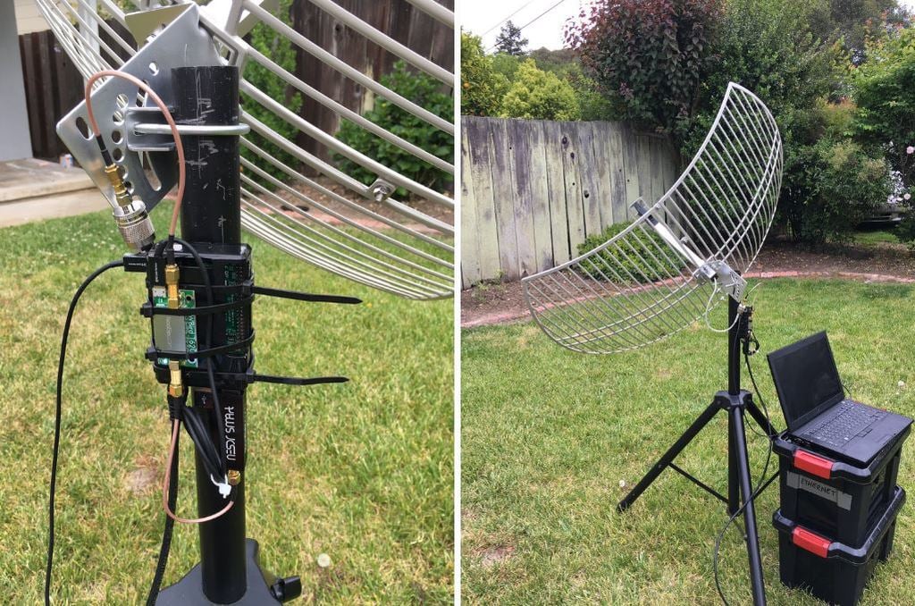
Over on Twitter and his github.io page, Pieter Noordhuis (@pnoordhuis) has shared details about his low cost RTL-SDR based GOES satellite receiving setup. GOES 15/16/17 are geosynchronous weather satellites that beam back high resolution weather images and data. In particular they send beautiful high resolution 'full disk' images which show one side of the entire earth. As the satellites are in geosynchronous orbit, they are quite a bit further away from the earth. So compared to the more easily receivable low earth orbit satellites such as the NOAA APT and Meteor M2 LRPT satellites, a dish antenna, good LNA and possibly a filter is required to receive them. However fortunately, as they are in a geosynchronous orbit, the satellite is in the same position in the sky all the time, so no tracking hardware is required.
In the past we've seen people receive these images with higher end SDRs like the Airspy and SDRplay. However, Pieter has shown that it is possible to receive these images on a budget. He uses an RTL-SDR, a 1.9 GHz grid dish antenna from L-Com, a Raspberry Pi 2, the NooElec 'SAWBird' LNA, and an additional SPF5189Z based LNA. The SAWBird is a yet to be released product from NooElec. It is similar to their 1.5 GHz Inmarsat LNA, but with a different SAW filter designed for 1.7 GHz GOES satellites. The total cost of all required parts should be less than US $200 (excluding any shipping costs).
Pieter also notes that he uses the stock 1.9 GHz feed on the L-com antenna, and that it appears to work fine for the 1.7 GHz GOES satellite frequency. With this dish he is able to receive all three GOES satellites at his location with the lowest being at 25 degrees elevation. If the elevation is lower at your location he mentions that a larger dish may be required. It may be possible to extend the 1.9 GHz L-Band dish for better reception with panels from a second cheaper 2.4 GHz grid dish, and this is what @scott23192 did in his setup.
For software Pieter uses the open source goestools software that Pieter himself developed. The software is capable of running on the Raspberry Pi 2 and demodulating and decoding the signal, and then fully assembling the decoded signal into files and images.
In the past the Outernet project operated on L-band frequencies, and for the service they manufactured a number of active L-band active ceramic patch antennas for use with RTL-SDR dongles. Outernet has since moved on to faster Ku-band delivery, and hence their old L-band antennas can no longer be used for their service. There are a few of these patch antennas left over in Outernet's stock and they are currently selling them on eBay for US $29 + shipping.
Although no longer useful for Outernet, these antennas are still very useful for receiving other L-band services such as STD-C SafetyNET and AERO. SafetyNET is a text broadcast intended for sailors at sea, but contains many interesting and potentially useful messages for others too. Often they transmit data like military sea live firing warnings, reports of marine pirate activity, search and rescue reports, scientific vessel reports as well as weather reports. AERO is the satellite version of ACARS, and is used by aircraft to communicate with text messages to and from ground stations. L-Band AERO signals only contain information from the ground station up to the aircraft. For air to ground you'll need a C-band receiver set up. AERO is the satellite communications protocol that was so heavily centered on during the MH370 flight disappearance investigation.
In the past we've reviewed the Outernet L-band ceramic patch and found it to work very well. Certainly STD-C and AERO signals are easy to receive with the antenna if you point it at the satellite. The antenna requires bias tee power and can easily be used in combination with the bias tee on our RTL-SDR V3 dongles. The onboard filter helps reduce problems from interfering signals, but restricts reception to 1525 - 1559 MHz, so Iridium signals cannot be received with this antenna.
The L-Band Active and Filtered Ceramic Patch Antenna.
GOES 15/16/17 are geosynchronous weather satellites that beam back high resolution weather images and data. In particular they send beautiful high resolution 'full disk' images which show one side of the entire earth. As the satellites are in geosynchronous orbit, they are quite a bit further away from the earth. So compared to the more easily receivable low earth orbit satellites such as the NOAA APT and Meteor M2 LRPT satellites, a dish antenna, good LNA and possibly a filter is required to receive them. However fortunately, as they are in a geosynchronous orbit, the satellite is in the same position in the sky all the time, so no tracking hardware is required.
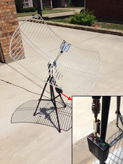
In the tutorial RSP2user notes that he's been using a $16 2.4 GHz WiFi grid dish antenna and the NooElec SAWbird LNA. In the past we've also seen GOES reception from Pieter Noordhuis who used a 1.9 GHz grid antenna from L-Com which seems to be a better match to the 1.7 GHz GOES frequency. However, 2.4 GHz WiFi grid antennas are much more common and therefore much cheaper. In the past there has been debate on whether or not these cheaper WiFi antennas would be good enough for GOES, so it's good to see that the cheaper option is confirmed to work, at least for the satellite elevations found in the RSP2user's part of the USA.
The SAWBird is a 1.7 GHz LNA which is required to improve SNR by reducing system noise figure, and to filter any interfering out of band signals. The SAWbird is currently not available for public sale, but NooElec have noted that it is due to be released soon. RSP2user also notes that the polarization of the dish is important, so the dish may need to be rotated, and also that flipping the secondary reflector significantly increases the gain at 1.69 GHz.
For software the XRIT demodulator from USA-Satcom for a small fee is used together with the SDRplay RSP2. As seen by Pieter Noordhuis' results, it's also possible to receive these signals with an RTL-SDR and Pieters free software. So it may be possible to reduce the costs of a GOES reception system by using an RTL-SDR, SAWBird and 2.4 GHZ WiFi grid antenna. With those components the total cost would be well under $100.
As a bonus, in later posts on his forum thread, RSP2user shows that the system can also be used to receive HRPT images from the low earth orbit NOAA 19 satellite by hand tracking the antenna as the satellite passes over.