Quantcast
Channel: satellite – rtl-sdr.com
Viewing all 254 articles
Browse latest View live

Preorder Sale: Active L-Band 1525-1660 Inmarsat and Iridium Patch Back In Stock for $44.95

$
0
0

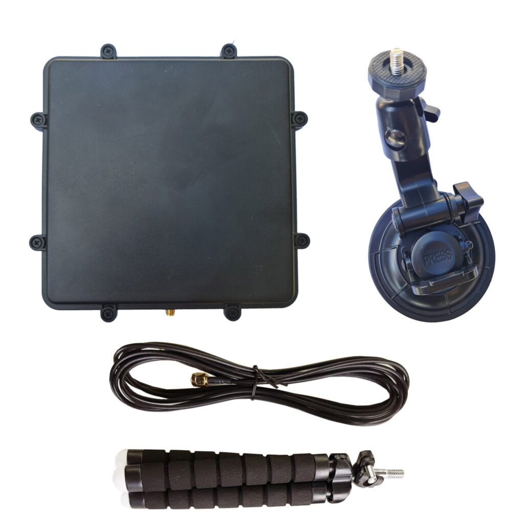
We have just received stock of our new L-band active patch antenna design. The antenna is designed for receiving L-band satellites such as Inmarsat, Iridium, GPS and other satellites that transmit between 1525 - 1660 MHz (please note that you cannot use it for weak signals that require a dish like HRPT or GOES). The antenna comes as a set with a large suction cup, 3M RG174 extension cable and bendable tripod to help with mounting. Preorder pricing is US$44.95 including free worldwide shipping to most countries shipped from our warehouse in Shanghai. At the end of this week pricing will rise to the standard cost of US$49.95. Amazon stock will require time, and won't be in for at least 6+ weeks.

Please see our store to order the unit

Like our previous patch design, this is an actively amplified antenna as it contains a built in low noise amplifier which takes power from a 3.3 - 5V bias tee. This power is available from from our RTL-SDR Blog V3 dongles, and other SDRs like the Airspy, HackRF and SDRplay. It also has a built in SAW filter after the LNA to help reduce terrestrial interference.

Compared to the previous design the new patch is larger (175 x 175 mm) with higher gain and wider radiation pattern. This allows for much easier pointing of the antenna and for much stronger signals. The upper frequency range has also been extended to 1660 MHz from 1625 MHz. The included suction cup is also much larger allowing for the patch to point at more angles without being restricted by the window. The patch is enclosed within a new weatherproof plastic enclosure. 

L-Band Patch with Accessories
L-Band Patch Mounting Examples

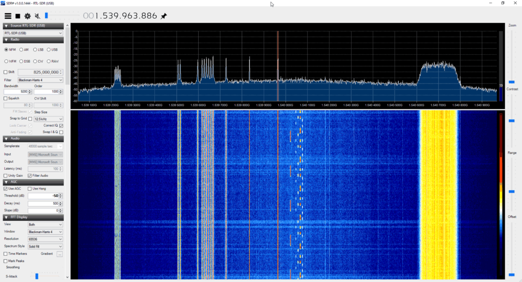
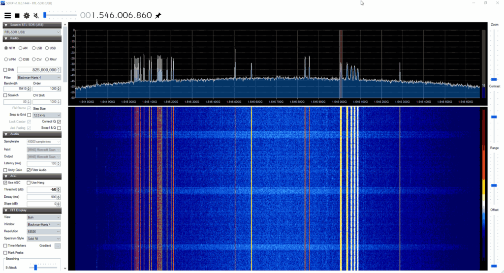
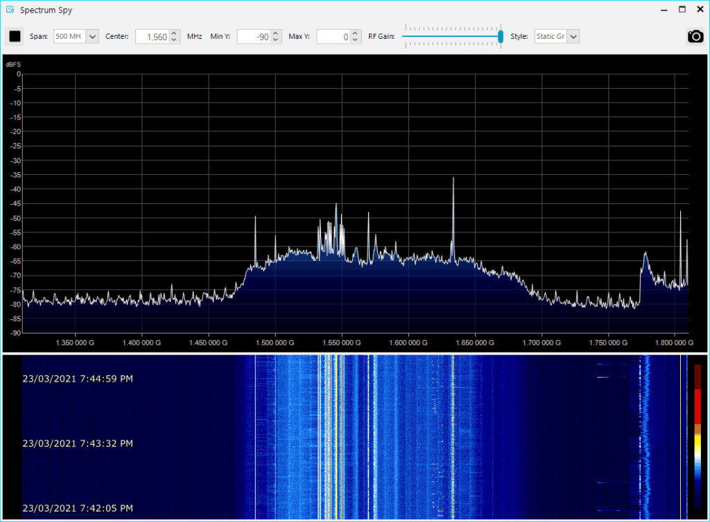
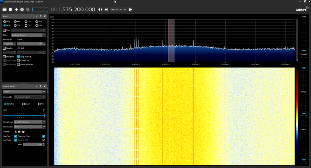
The screenshots below show the patch receiving various signals like AERO, STD-C and Iridium

Inmarsat Reception
Inmarsat Reception
Airspy Showing Patch Bandwidth
GPS "hump" visible

Usage Tips

  • The antenna should be used with one meter or more of coax cable. It may perform poorly if the RTL-SDR is placed right at the antenna due to interference. If you want to run very long cable, then low loss coax should be used. 
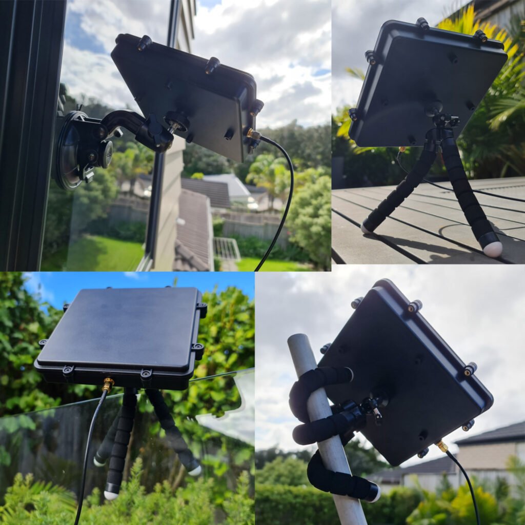
  • The patch can be used flat, or angled towards the satellite. Angling it towards the satellite will yield significantly higher gain.
  • If you have very strong cell phone interference in your area, try using the patch a bit lower to the ground, and use buildings to block the interfering signal.
  • If you want to mount this on a car roof, you can use a standard mag-mount camera adapter.
  • When using the suction cup, ensure you wipe down the cup and the window surface before sticking it on. Have a backup plan in case the suction fails.

What can you do with this antenna?


SMOG-1 PocketQube Satellite Successfully Launched and in Orbit

$
0
0

Thank you to Zoltan Doczi (HA7DCD) for submitting news about the successful launch and first reception of the SMOG-1 PocketQube Satellite (which is only 5x5x5cm in size). The pre-launch press release by Tech University of Budapest is available here, and the SMOG-1 Facebook page provided additional updates.

Back in April 2020 we first heard about the launch of SMOG-P which was the first functioning 1-PocketQube satellite, and was designed to measure electromagnetic pollution (electrosmog) from space. SMOG-1 is the successor to SMOG-P and it carries a similar mission to measure electromagnetic pollution generated by human activity in space around the Earth. Interestingly it also carries a magnetically lossy material under it's solar panels which is to act as a brake, reducing the 18-25 Orbital lifespan, thus reducing space trash after the primary mission is complete.

According to the receive and decoding instructions provided by Levente Dudas, SMOG-1 can be received with a simple satellite antennas, such as a handheld Yagi, Turnstile, Dipole or quadrifilar-helix antenna. The telemetry frequency is 437.345 MHz with callsign HA5BME. For the radio an RTL-SDR connected to a Raspberry Pi can be used, and the telemetry decoding software can be found on GitLab

SMOG-1 can be tracked here, although Zoltan mentions that the TLEs may not yet be accurate for several more days or weeks, as was seen with the launch of SMOG-P as well. The reason is that it is difficult for the NORAD radars to see these tiny PockQube satellites which is required for TLE generation.

Building a GOES-16 Antenna out of Trash, Cardboard and Foil Tape

$
0
0

Over on his YouTube channel saveitforparts has uploaded a video showing how he was able to modify and old DirectTV satellite dish found in the dumpster with cardboard and foil in order to receive images from the GOES-16 geostationary weather satellite.

I wanted to download images from the GOES-16 weather satellite, but didn't have a big enough satellite dish. So I made one out of an old TV dish, cardboard, and aluminum tape! Amazingly this actually works, and I was able to pull live pictures of the earth off the satellite in geostationary orbit! The cardboard won't last long-term, so I'm looking for an antique C-band dish that I can set up as a more permanent solution. However, for a cheap and expedient ground station, this worked pretty well!

Satellite Ground Station With Trash, Cardboard, and Foil Tape!

NOAA-2 Returns from the Dead

$
0
0

Satellites can stay in orbit for years after their decommissioning date. Although they are turned off, often after many years they can turn on again as the battery chemicals begin to break down, eventually allowing electricity directly to the satellite systems whenever the solar panels are in light. We've seen this phenomenon occur with various decommissioned satellites.

Recently it was discovered by amateur radio satellite watcher Scott Tilley that NOAA-2 appears to be actively transmitting again in the L-band at 1697.5 MHz. NOAA-2 is a weather image satellite that was operational from 1972 - 1975.

Next over on his blog Derek OK9SGC was able to confirm reception of the signal, make a recording, and then with the help of @Xerbo10 discovered that you can actually receive an image from it. However as is to be expected the camera is not actually operational and all you get is a few grey lines indicating voltage calibration and sync telemetry.

It's unknown how long the satellite will stay undead, but if you manage to receive it let us know in the comments.

NOAA-2 Revival Signal and APT Image

Two reviews of our new L-Band Patch Antenna + Stock Update

$
0
0

Last month we released our new L-band active patch antenna for sale, and not too long after we had a review from Frugal Radio praising it. We now have two more YouTube reviews available to share.

The first is from Tech Minds who does a teardown and demonstrates it receiving and decoding the Inmarsat STD-C NCS channel, receiving and decoding GPS and receiving Iridium signals. The second is from Mike Ladd from SDRplay, who tests it with an SDRplay RSP1A software defined radio. He shows that the patch works perfectly with an RSP1A, and demonstrates it receiving and decoding STD-C while mounted on the dash of his vehicle.

L-Band Patch Stock Availability Note: We note that we are already close to selling out of the first batch of these units as they sold much faster than expected! New sales of this patch are currently backordered but we expect to have a few more units from this first batch available by the end of next week. Also the freighter with Amazon USA stock should be arriving any day now, but it could still take a few weeks to get through the port and reach the warehouse due to the current port delays.

The second production batch of this antenna might still be a while away due to the electronic component shortage crisis occurring now, so if you were thinking about picking one up, please order ASAP.

RTL-SDR BLOG L-BAND Patch Antenna Version 2 - Inmarsat - Iridium - GPS

SDRplay RSP1a - RTL SDR Blog L-Band Patch antenna

Building an Automated NOAA and Meteor Weather Satellite Image Collector with RTL-SDR

$
0
0

Over on his YouTube channel saveitforparts has uploaded a video showing how he has built an automated weather satellite image collector for the NOAA APT and Meteor M2 LRPT satellites. The video shows a time lapse of him building a QFH antenna, and how he's mounted a Raspberry Pi and RTL-SDR inside a waterproof enclosure attached to the antenna mast. He goes on to show how he's automating the system with the Raspberry-NOAA V2 software

Automated Home Weather Station (Satellite Image Collector)

Decoding NOAA on an Debian Chrooted Android Smartphone

$
0
0

Over on Reddit Ian Grody (u/DutchOfBurdock) has posted about his success in using a modded Android smartphone to run an RTL-SDR Blog V3 and NOAA decoder software all within the phone itself.

In the past we posted about Ian's work in getting rtl_power scans to work in conjunction with the Tasker app, in order to generate automated frequency scans on his phone on the go. His more recent work from the past year includes showing us how it's possible to install Debian chroot on an Android phone, and run Linux software like GQRX, GNU Radio, DSD, rtl_433, multimon-ng and dump1090 directly on the phone with an RTL-SDR.

His latest Reddit post shows that the NOAA-APT decoder also runs well on the Debian chroot, leading to a truly portable NOAA decoding setup. He notes that he is now working on the possibility of Meteor M2 decoding on the phone.

Below is his video from last year demonstrating SDR GQRX and GNU Radio running on the Debain chrooted phone.

YouTube Video

Frugal Radio: How To Decode L band Satellite ACARS and CPDLC messages with JAERO and your SDR

$
0
0

In the latest episode of his YouTube series on Aviation monitoring Rob explores how to decode L-band satellite ACARS (Aircraft Communication Addressing and Reporting System) and CPDLC (Controller Pilot Data Link Communications) messages using JAERO, an SDR like an RTL-SDR, and a appropriate L-band antenna such as our RTL-SDR Blog Active L-Band Patch (currently out of stock).

In the video Rob shows examples of what you might receive such as CPDLC ATC instructions, digital ATIS information, arrival information and suggested landing data configuration instructions. He goes on to show satellite coverage maps, what hardware is required to receive these signals, and finally how to setup the receiving and decoding software.

YouTube Video


Using an RTL-SDR Dongle to Receive Pictures from the ISS

$
0
0

Over on YouTube we've seen a good video from channel Ham Radio DX where presenter Hayden shows how to use an RTL-SDR to receive slow scan television (SSTV) images from the International Space Station (ISS). Often the ISS will transmit SSTV images down to earth on the VHF 2 meter bands as part of an event. With an RTL-SDR and simple antenna it's possible to receive those images.

In the video Hayden discusses the SSTV transmission, and demonstrates some SSTV decoding happening in real time as the ISS passes over his location. If you're looking to get started in ISS SSTV reception, this is a good video to get an idea of what's involved. He finishes the video with some useful tips for reception.

YouTube Video

Elektro-L3 Geostationary Weather Satellite: Easy to Receive LRIT Signal Being Tested

$
0
0

Back in September 2020 we posted about the release of an X-Band decoder for the Elektro-L2 and Elektro-L3 Russian geostationary satellites. These satellites are receivable from Europe, the Middle East, Asia, Africa, South America and Australia. Unlike the HRIT and LRIT L-band transmissions from other geosynchronous satellites like GOES and GK-2A, the X-band Elektro signal is quite difficult to receive, requiring a large dish and more expensive hardware.

However we've recently seen exciting news on Twitter that a new L-band LRIT transmission has been activated on Elektro-L3. Like the Korean GK-2A satellite, this L-band LRIT transmission at 1691 MHz should be much easier to receive requiring only a WiFi dish, SAWBird GOES LNA and an RTL-SDR. We haven't yet confirmed if like GK-2A, the smaller 600 x 400 mm WiFi dish is sufficient, or if Elektro requires the larger 600 x 1000 mm dish size. (See our GOES satellite and GK-2A tutorial for information about the hardware being discussed in this paragraph.)

We note that the Elektro-L3 signal appears to be in testing, and the transmission could be turned on and off, or even turned off permanently. The transmission schedule is also not yet clear although in this recent tweet @HRPTEgor has mapped out some current transmission times for Eletro-L3.

It is hoped that LRIT will also eventually be activated on Elektro-L2, and perhaps even HRIT will be activated too. It is also exciting that more Elektro-L satellites are planned to be launched from 2022 onwards and we expect those to have hopefully LRIT and HRIT transmissions as well. To add further excitement, it is hoped that the L3 LRIT activation means that a LRIT or HRIT signal will be activated on the high elliptical orbit (HEO) northern hemisphere Arctic monitoring ARKTIKA-M1 satellite launched in Feb 2021, as this satellite is derived from the Elektro-L design.

The LRIT activation of Elektro-L3 hopefully means that Europeans should finally have access to a geostationary weather satellite that can be easily received with modest low cost hardware. The current coverage map from Orbitron of the two Elektro satellites is shown below (note that Elektro-L2 LRIT does not appear to have been activated yet).

Elektro-L2 and Elektro-L3 Coverage (Currently only Elektro-L3 LRIT transmissions have been discovered)

Over on Twitter @aang254 has noted that he has already updated his satdump software, adding support for Elektro LRIT decoding, and adding support for all of the available channels and for color. Satdump is available as a binary for Windows, and on Linux can be built from source. Experimentally, Satdump can also be built and run on Android.

The Tweet from @aang254 provides a nice sample image of what can be received.

Layering Geo-Spatial Fire Data onto GOES Satellite Imagery

$
0
0

Thank you to Carl Reinemann (aka usradioguy) for writing in and sharing with us how he has developed a script to layer FIRMS data (Fire Information for Resource Management System US / Canada) onto GOES satellite images (usradioguy blog post) that can be received with an RTL-SDR. We have a tutorial on GOES reception here.

The script is a Windows batch file that downloads FIRMS data from the internet every 12 hours, then converts that data into a format that can be processed by goestools. Once converted the resulting JSON file is uploaded to the Raspberry Pi running goestools. A custom goestool process is then used to layer the data onto the received images.

The result is accurate red polygons on the satellite image in areas where fires have been recorded. With this data visualized it is easy to see where smoke seen on the satellite images is coming from. For example, the image below shows the location of wildfires in the Western USA and the resulting smoke trailing across the continent.

Carl has also tested the fire data layer with GK-2A and Himawari-8 and notes that it works well with images from those satellites as well. 

Fires data in Western USA layered on top of received GOES satellite images.

SDR Talks from the SDRMakerspace Online Presentation

$
0
0

Thank you to Robert for letting us know about these videos from the "ESA ARTES SDR MakerSpace Presentations" from September 6-8, 2021 which are now available on YouTube. 

Libre Space Foundation ( Greece) and the Institute of Reconfigurable & Embedded Digital Systems(REDS) of the Haute Ecole d’Ingénierie et de Gestion du Canton de Vaud – HEIG-VD (Switzerland) have been implementing a number of smaller projects as part of an Software Defined Radio MakerSpace of the European Space Agency.

This activity is part of the ARTES programme of ESA that supports innovation in satellite communications.

The findings were presented in three 2-hour slots in the afternoon at 15:00 CEST (for which you are requested to register separately) on Mon 6, Tue 7 and Wed 8 September 2021.

  • Monday 6 Sep was focused on the evaluation of various SDR boards and FPGA tools chains. High-rate direct sampling by SDR’s and SDR on Android will also be presented.
  • Tuesday 7 Sep was dedicated to building blocks that have been implemented as open source developments for Gnuradio, such as gr-leo, gr-ccsds, gr-soapy etc.
  • Wednesday 8 Sep was mainly about the combination of SDR and AI/ML to do signal detection and classification. In addition, an SDR testbed and spectrum monitoring will be presented.

The talks cover various SDR topics related to satellite observing. Some talks we were interested in are highlighted below, but the full list can be found on the SDRMakerspace website, or the SDRMakerspace playlist on the Libre Space Foundation YouTube channel.

YouTube Video

LeanHRPT – A set of tools for the manipulation of HRPT data

$
0
0

Over on Reddit u/Xerbot has posted about the release of his new software called "LeanHRPT". When combined with a software defined radio, this software can be used to decode and view HRPT weather satellite images received from satellites such as NOAA, Meteor, MetOp and FengYun. We note that unlike APT and LRPT weather satellite signals which transmit in the VHF bands, HRPT signals are generally at ~1.70 GHz and require a motorized or hand tracked satellite dish to receive. u/Xerbot writes:

LeanHRPT is a flexible, easy to use and powerful set of tools for the manipulation of HRPT data (maybe I could be convinced to add LRPT support).

When used properly LeanHRPT Decode can generate (almost) L1B data usable in actual land/weather observation, or just pretty images :)

You can get it here: https://github.com/Xerbo/LeanHRPT-Decode

The LeanHRPT project also contains LeanHRPT Demod, as you probably guessed, a HRPT demodulator. It features an incredibly high sensitivity as well as being able to do both realtime (through SoapySDR) and offline demodulation (baseband).

You can get it here: https://github.com/Xerbo/LeanHRPT-Demod

LeanHRPT Applying a map overlay on FengYun

Receiving Starlink Beacons with an RTL-SDR and LNB

$
0
0

Derek OK9SGC has recently posted a write-up of how they’ve been able to receive the Ku-band beacon signals from the Starlink constellation of communication satellites continually launched by SpaceX since 2015. While we recently covered Starlink Beacons being captured with a HackRF Supercluster Derek has noted that receiving the beacons requires little more than an LNB, a low-cost SDR such as the RTL-SDR V3 and a power injector to provide 12V DC to the LNB. Derek notes that a dish is not even required as the beacons transmit with high power.

Starlink Beacon Receiver Setup

Due to the low earth orbit and thus high speed of travel of the Starlink constellation you’ll notice strong Doppler effect drifts in your received signal. Derek notes that it may be interesting to perform Doppler analysis on the satellites with the satellite tracking toolkit for radio observations (strf) software. He also noted that in the 30 minutes he was receiving for, there was almost no point in time where a beacon was not being received, indicating that the Starlink constellation is close to achieving 100% sky coverage. 

Derek has made the process easy to understand and illustrates just how easy it is to listen to these beacon signals. Of course we note that these are just the beacons, and they carry no data. Still they are fun signal to receive, and doppler analysis could reveal interesting information about orbits. 

Starlink beacons shown in a fast FFT (LEFT), and slow FFT (RIGHT)

Technical Details on an SDR Supercluster with Eight HackRFs

$
0
0

A few weeks ago we posted about Reddit member u/OlegKutkov who used his HackRF supercluster to receive Starlink beacons, but details on the HackRF supercluster project itself were a little sparse. Now Oleg has posted a full description about the HackRF supercluster, noting that the 8 HackRF's in the system can provide up to 160 MHz of live monitoring bandwidth.

Oleg shows how each of the boards are connected to the same GPS disciplined 10 MHz clock source, how it uses an RF splitter with LNA and how it requires 8 separate host controllers connected to individual PCIe lines in his computer system to overcome the USB2.0 data bandwidth limits. He also shows the GNU Radio script he's created that combines the 8 sources into one.

Oleg writes how he's using the HackRF supercluster together with a TV Ku-Band LNB and satellite dish for wideband satellite monitoring.

HackRF Supercluster Block Diagram
The HackRF Supercluster

SDRAngel Features Overview: ADS-B, APT, DVB-S, DAB+, AIS, VOR, APRS, and many more built-in apps

$
0
0

SDRAngel is a general purpose software defined radio program that is compatible with most SDRs including the RTL-SDR. We've posted about it several times before on the blog, however we did not realize how much progress has occurred with developing various built in plugins and decoders for it.

Thanks to Jon for writing in and sharing with us a demonstration video that the SDRAngel team have released on their YouTube channel. From the video we can see that SDRAngel now comes stock with a whole host of built in decoders and apps for various radio applications making it close to an all-in-one SDR platform. The built in applications include:

  • ADS-B Decoder: Decodes aircraft ADS-B data and plots aircraft positions on a map
  • NOAA APT Decoder: Decodes NOAA weather satellite images (in black and white only)
  • DVB-S: Decodes and plays Digital TV DVB-S and DVB-S2 video
  • AIS: Decodes marine AIS data and plots vessel positions on a map
  • VOR: Decodes VOR aircraft navigational beacons, and plots bearing lines on a map, allowing you to determine your receivers position.
  • DAB+: Decodes and plays DAB digital audio signals
  • Radio Astronomy Hydrogen Line: With an appropriate radio telescope connected to the SDR, integrates and displays the Hydrogen Line FFT with various settings, and a map of the galaxy showing where your dish is pointing. Can also control a dish rotator.
  • Radio Astronomy Solar Observations: Similar to the Hydrogen line app, allows you to make solar measurements.
  • Broadcast FM: Decoding and playback. Includes RDS decoding.
  • Noise Figure Measurements: Together with a noise source you can measure the noise figure of a SDR.
  • Airband Voice: Receive multiple Airband channels simultaneously
  • Graves Radar Tracker: For Europeans, track a satellite and watch for reflections in the spectrum from the French Graves space radar. 
  • Radio Clocks: Receive and decode accurate time from radio clocks such as MSF, DCF77, TDF and WWVB.
  • APRS: Decode APRS data, and plot APRS locations and moving APRS enabled vehicles on a map with speed plot.
  • Pagers: Decode POCSAG pagers
  • APRS/AX.25 Satellite: Decode APRS messages from the ISS and NO-84 satellites, via the built in decoder and satellite tracker.
  • Channel Analyzer: Analyze signals in the frequency and time domains
  • QSO Digital and Analog Voice: Decode digital and analog voice. Digital voice handled by the built in DSD demodulator, and includes DMR, dPMR and D-Star.
  • Beacons: Monitor propagation via amateur radio beacons, and plot them on a map.

We note that the video doesn't show the following additional features such as an analog TV decoder, the SDRAngel "ChirpChat" text mode, a FreeDV decoder and several other features.

YouTube Video

A Comprehensive Beginners Guide to HRPT Weather Satellite Reception

$
0
0

Over on his blog Derek (OK9SGC) has recently uploaded a very comprehensive beginners guide to receiving HRPT weather satellite images. HRPT reception can be a little daunting as it requires a good L-Band dish setup which involves choosing and building a feed, and importantly, a way to track the satellite with the dish as it moves across the sky. Tracking can be achieved manually by hand, but that can be very difficult and so a motorized tracking mount is recommended.  

This is unlike the much easier to receive NOAA APT or Meteor LRPT satellite signals in the VHF band which can be received by a V-dipole antenna, or the geostationary GOES HRIT satellites that can be received with a WiFi grid dish and LNA. Both of which do not require tracking.

The advantage of HRPT however, is that you end up with high resolution, close-up, and uncompressed images of the earth. For example Derek notes that NOAA APT gives 4km/px resolution, and Meteor LRPT gives much better 1km/px resolution but it is heavily compressed. Whereas HRPT gives peak resolutions of 1km/px uncompressed. There are also nine satellites in operation sending HRPT, so there are more opportunities to receive.

Derek has created a very comprehensive beginners guide that covers almost everything from purchasing and building the hardware, to finding and tracking the satellites, to setting up the software and decoding images. He notes that an RTL-SDR can be used as the receiver, and that a WiFi dish with GOES SAWBird LNA can work, although the difficult tracking requirements are still there so a smaller offset dish with custom helix feed might be preferred. Derek also provides useful tips, like the fact that the NOAA15 HRPT signal is quite a lot weaker than others.

Images from Dereks HRPT Guide

Receiving X-Band Images from the Arktika-M1 Arctic Monitoring Satellite

$
0
0

Recently on Twitter @arvedviehweger (Arved) has tweeted that he has successfully received images from the Russian Arctic monitoring satellite known as ARKTIKA-M1, via it's X-band downlink at 7865 MHz. We've reached out to Arved and he's provided the following information on his setup and how he's receiving and decoding the images.


The Arktika-M1 satellite is a Russian weather satellite which operates in a HEO orbit. It was launched in February 2021 and has downlinks on multiple bands. The main payload downlink for the imagery is on 7865 MHz (which is also known as the lower X-Band). The satellite only transmits imagery on the X-Band at the moment, it is currently unknown whether it will ever transmit any image data on L-Band.

For Amateur reception that means having access to X-Band RF gear. It usually consists of a low noise pre-amplifier and a downconverter to convert 7865 MHz down to a lower frequency for easier reception with a high bandwidth SDR such as the LimeSDR, a USRP etc.

In my personal setup I use a surplus pre-amplifier made by MITEQ (around 36dB of gain, 1dB NF), my own self-made DK5AV compact X-Band downconverter and a LimeSDR-USB.

The L-Band gear is mounted on top (helix and the pre-amp behind it) and the X-Band gear is right below. From left to right you can see the feed, the downconverter (silver box) and the LNA (mounted to a heatsink and a fan). Recording is done with a LimeSDR-USB running at a sample rate of 50 MSPS. The satellite transmits every 15 minutes once it reaches its apogee, each transmission including the idle period lasts for about 10 minutes. Some pictures of the idle transmission and the actual data transmission can be found in this Tweet, [noting that Idle = more spikes, actual data looks weaker]:

Depending on the geographical location a rather large satellite dish is also required for Arktika-M1. Reception reports all over Europe clearly show that the satellite has a beamed antenna (similar to ELEKTRO-L2).

In my setup I can get away with a 2.4m prime focus dish (made by Channel Master) in North Eastern Germany. It produces around 9 - 10 dB of SNR in the demod of @aang254’s excellent SatDump software. Anything above 5dB will usually result in a decode but since the satellite does not have any FEC you will need more than that for a clean picture. (Image of SNR in Satdump)

Receiving Analog TV from Turkmenistan Unintentionally Bouncing off a Russian Military Satellite

$
0
0

Over on Twitter @dereksgc has been monitoring the 'Meridian' communications satellites, which are Russian owned and used for civilian and military purposes. The satellites are simple unsecure repeaters, meaning that actually anyone with the hardware can transmit to them, and have their signal automatically rebroadcast over a wide area. This has been taken advantage of recently by anti-Russian invasion war activists who have been trolling the satellite with SSTV images of the Ukrainian flag, as well as audio.  

Apart from intentional abuse, a side effect of being an open repeater is that sometimes the satellite can pick up powerful terrestrial signals unintentionally, such as analogue broadcast TV from Turkmenistan. Over on his blog, @dereksgc has written up an excellent post documenting the background behind this finding, his entire setup involving the hardware he's using and how he's aligning with the satellite, and what software he is using to decode the TV signal. In his hardware setup he notes that he uses a HackRF, but that a RTL-SDR would suffice.

Lon.TV Demonstrates Decoding Various Digital Signals with RTL-SDR

$
0
0

Tech YouTuber Lon.TV has recently uploaded a video demonstrating how to identify and decode various digital transmissions with an RTL-SDR dongle. In the video he explains how to use VB Cable to pipe audio from SDR# into various decoders, and then goes on to show DMR, APRS, POCSAG, L-Band AERO, FT8, and JS8/JS8CALL all being decoded via an RTL-SDR Blog V3 dongle.

YouTube Video

Viewing all 254 articles
Browse latest View live